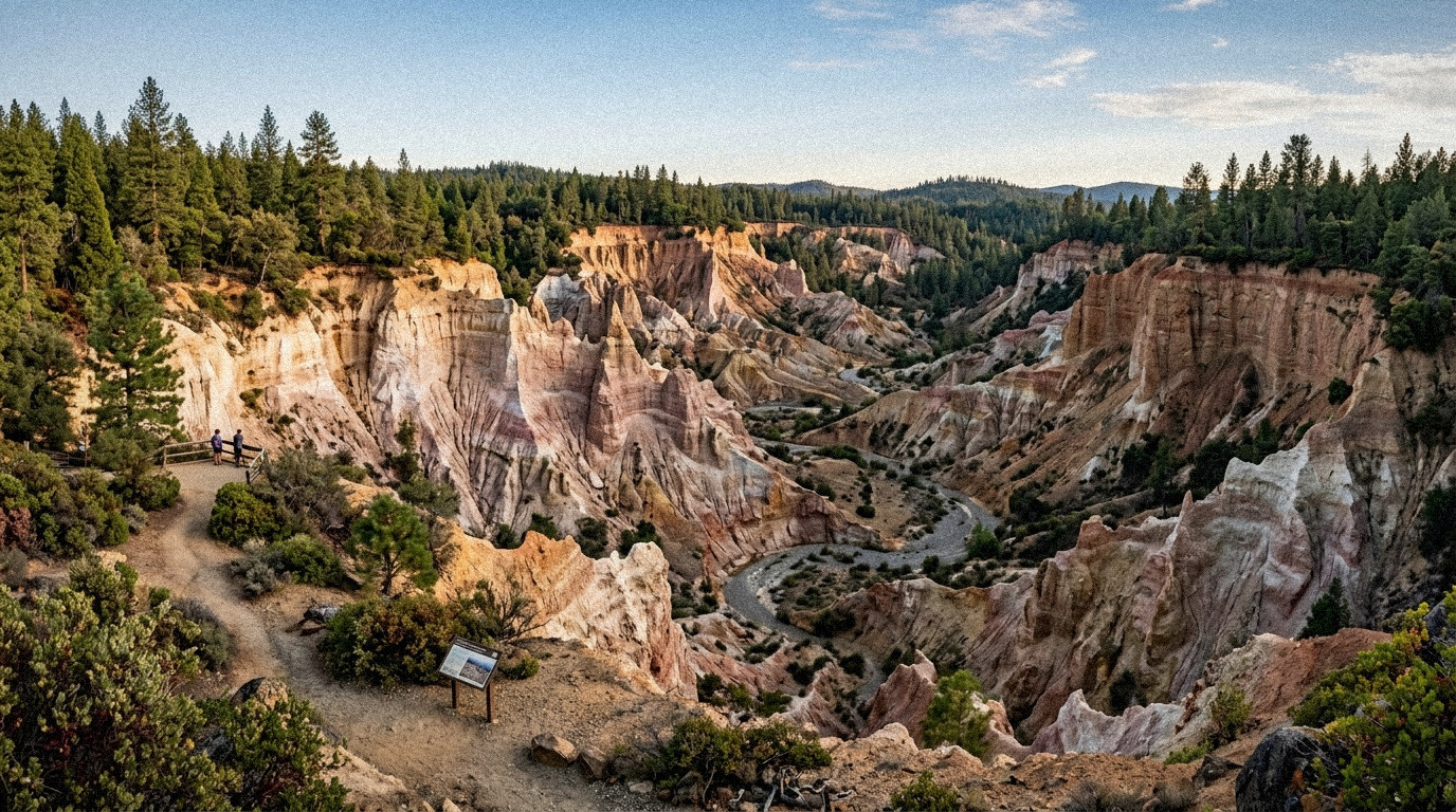
Deep in the pine-scented folds of the Northern Sierra foothills, roughly 26 miles northeast of Nevada City, the earth splits wide open into an astonishing, lunar amphitheater. Strata of chalk-white kaolin clay, crimson gravel, and golden sandstone rise hundreds of feet into the sky like miniature Bryce Canyon hoodoos. But unlike the natural canyons carved by millions of years of wind and river melt, this gargantuan crater—over a mile long, 3,000 feet wide, and nearly 600 feet deep—was created in less than two decades by pure human avarice and an industrial invention capable of tearing mountains to shreds: hydraulic mining.
This is Malakoff Diggins State Historic Park, California’s largest historic hydraulic gold mine. It is both a stark geological monument and a 19th-century ecological cautionary tale, preserving the ground zero where industrial technology collided head-on with agriculture, sparking America’s very first environmental protection law.
When Water Became an Explosive Weapon: The Hydraulic Boom
By the mid-1850s, the "easy" placer gold in California’s rivers was gone. The forty-niners had panned every sandbar, shoveled out the gravel bars, and redirected the streams. But geologists and seasoned prospectors realized that millions of years ago, tertiary gravel channels flowed across California, depositing immense quantities of heavy gold beneath hundreds of feet of soil and cemented rock.
Getting to that deeply buried gold with hand picks and shovels was mathematically impossible. In 1853, an enterprising miner named Edward Matteson rigged up a canvas hose and nozzle to blast a hillside with water. The experiment worked with frightening efficiency. Over the next decade, capital investment poured into Nevada County. Canvas gave way to heavy iron pipes, and small hoses evolved into gargantuan water cannons known as "Monitors" or "Little Giants".
At Malakoff Diggins, the North Bloomfield Gravel Mining Company built an astounding infrastructure network: over 100 miles of wooden flumes, ditches, and massive storage reservoirs that channeled snowmelt from the high Sierra crest under crushing gravitational head pressure. Emerging from eight-inch monitor nozzles at speeds exceeding 100 miles per hour, these water cannons delivered kinetic energy equivalent to an artillery barrage. A monitor stream was so ferocious it would instantly kill a man who walked into its path or shatter a crowbar into shrapnel.
Night and day, deafening water jets pummeled the cliffs, dissolving millions of tons of ancient mountain into a violent slurry of liquid mud, boulders, and gravel. The slurry was funneled through the 7,800-foot-long Malakoff bedrock drainage tunnel, where thousands of pounds of liquid mercury lined wooden riffle boxes to capture the fine flour gold.
The Great Mud Inundation and the 1884 Sawyer Decision
Between 1866 and 1884, Malakoff Diggins washed an estimated 41 million cubic yards of earth down Humbug Creek and into the South Yuba River. Across the northern mines, hundreds of millions of cubic yards of mining debris choked downstream waterways.
The ecological consequence downstream in the Sacramento Valley was catastrophic. Riverbeds filled with sediment, raising water levels above surrounding agricultural plains. Cities like Marysville and Sacramento built towering levees, but during winter deluges, devastating floods submerged fertile farmland under thick, toxic "slickens" (mining silt laced with mercury). Riverboats could no longer navigate the choked Sacramento and Feather rivers, and orchards were suffocated under feet of gray gravel.
The brewing war between Sierra miners and valley farmers culminated in the historic federal court case Woodruff v. North Bloomfield Gravel Mining Co.. On January 7, 1884, Federal Circuit Court Judge Lorenzo Sawyer issued a groundbreaking, 225-page permanent injunction. Sawyer ruled that discharging mining debris into public streams constituted a public nuisance and was strictly forbidden.
The Sawyer Decision effectively sounded the death knell for large-scale hydraulic mining in California. More importantly, it established a radical new legal precedent in American jurisprudence: private industrial enterprises could not destroy public waterways and agricultural resources for corporate profit. It was, by all accounts, the birth of modern American environmental law.
Do not trust generic GPS navigation blindly when driving to the park! Google Maps often routes drivers up North Bloomfield Road from Highway 49, which includes a treacherous, narrow single-lane unpaved section with rough switchbacks and sheer drop-offs across Edwards Crossing. Instead, take Tyler Foote Crossing Road off Highway 49, cross the paved bridge at Purdon Crossing, and continue via Cruzon Grade Road. This route is paved almost the entire way and significantly easier on passenger vehicles.
Exploring North Bloomfield: A Preserved Gold Rush Ghost Town
When the mines shuttered overnight following the 1884 ruling, the bustling mining town of North Bloomfield—originally dubbed "Humbug" when early prospectors mistakenly thought the area was barren—froze in time. In its heyday, North Bloomfield was home to over 2,000 residents, boasting eight saloons, two hotels, a brewery, churches, bakeries, and dry goods emporiums.
Today, North Bloomfield is meticulously preserved by California State Parks. Strolling along its quiet, unpaved Main Street feels remarkably authentic:
- McKellican & Mobley General Store: Step inside to see original wooden counter shelves stocked with vintage 19th-century canned goods, dry goods packaging, kerosene lamps, and mining supplies.
- Historic St. Columcille’s Catholic Church & Schoolhouse: Built in the late 1860s, complete with original wooden school desks, chalkboards, and church belfry.
- King’s Saloon & Drugstore: Featuring period artifacts that tell the story of the diverse immigrant workforce that settled here, including Irish, Cornish, and Chinese miners.
- The Mining Museum: Housed in the old park visitor center, exhibiting massive cast-iron "Monitor" nozzles, giant pelton wheel castings, and historic photographs of the blasting in action.
Hiking the Diggins: Trails Through the Badlands
The park boasts more than 20 miles of hiking trails weaving through pine forests and directly across the floor of the mining pit:
- Diggins Loop Trail (3 miles): The park’s premier hike. Descends from the canyon rim directly onto the floor of the excavated badlands, winding beneath colossal pinnacles of white and pink sediment and passing the entrance of the historic bedrock drainage tunnel.
- Rim Trail (3 miles): Loops around the upper circumference of the crater, offering wide overlooks across the entire excavation basin, especially dramatic in late afternoon when low sunlight turns the cliffs brilliant shades of amber and rose.
- Humbug Creek Trail (4 miles one way): Follows the rushing mountain creek downstream through lush riparian alder and oak forests toward the South Yuba River, highlighting natural forest regeneration over the past 140 years.
Actionable Logistics: Planning Your Trip
Everything you need to know for a memorable excursion to Malakoff Diggins:
- Park Hours: Open year-round from sunrise to sunset. The Visitor Center and Museum open seasonally (generally weekends in spring/fall, and daily during peak summer).
- Day-Use Parking Fee: $10 per vehicle ($9 for seniors 62+). Automated self-pay iron ranger boxes are available when the entry kiosk is unstaffed.
- Camping at Chute Hill: The park features 30 developed family campsites, three rustic historic miner cabins for rent, and one group camp. Campgrounds feature potable water, flush toilets, and fire rings, but no RV hookups or hot showers. Reservations can be booked via ReserveCalifornia.
- Weather & Seasons: At 3,200 feet elevation, summer temperatures can reach the mid-90s, while winter brings crisp mountain air and occasional snow dustings. Spring is prime visiting season, with rushing creeks and blooming dogwood blossoms.
Comments